ASDC / Lidar Browse Images / CALIPSO - Products - STANDARD Lidar Browse Images for Production Release [V5.00] Browse Date [2009-04-20]

STANDARD LIDAR BROWSE IMAGES FOR PRODUCTION RELEASE [V5.00] BROWSE DATE [2009-04-20]

Return to STANDARD V5 Browse Page → → HOME

DATA AVAILABILITY
18.0%
Click for more details

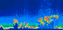
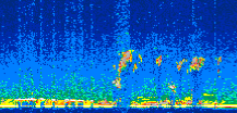
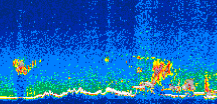
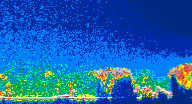
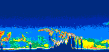
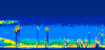
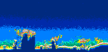
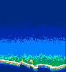
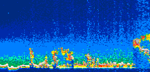
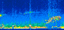
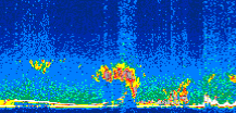
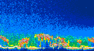
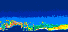
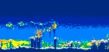
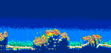
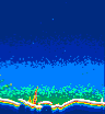
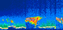
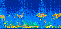
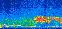
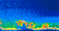
Displayed on this page are scaled, color-modulated, altitude-time images of CALIPSO attenuated backscatter (/km/sr) including:

  • 532 nm total (parallel + perpendicular) attenuated backscatter
  • 532 nm perpendicular attenuated backscatter
  • 1064 nm total attenuated backscatter

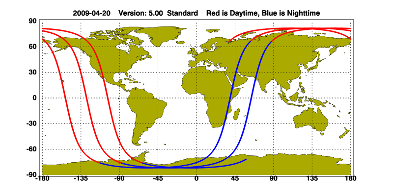
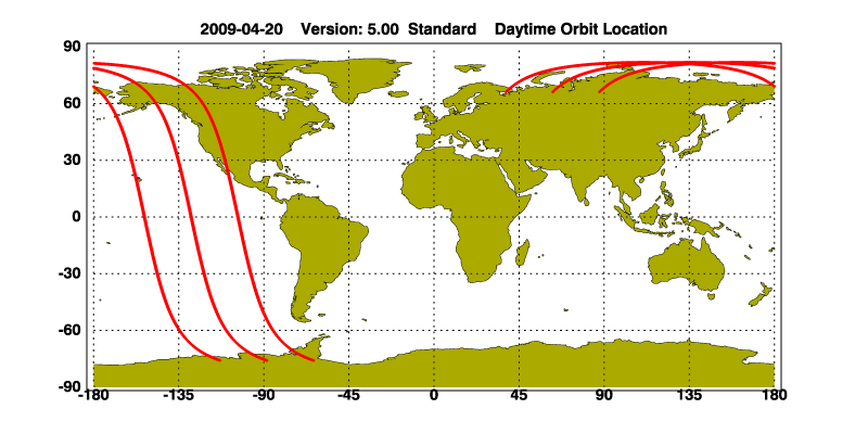
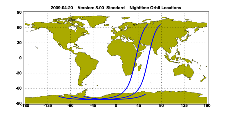
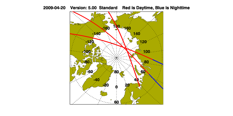
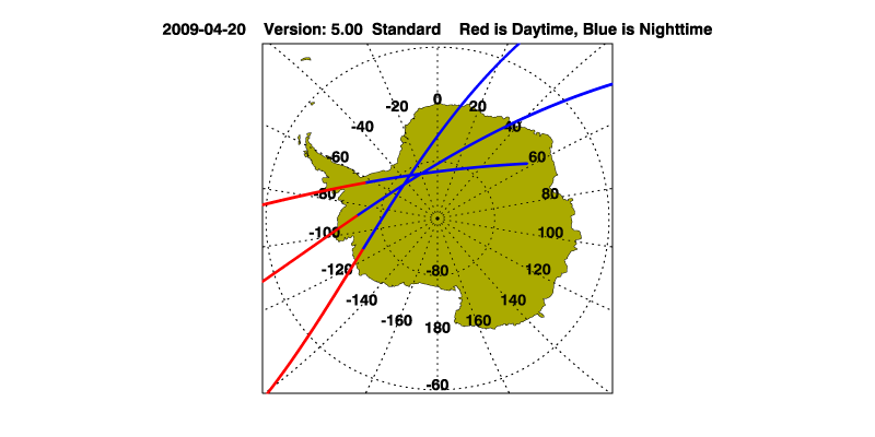
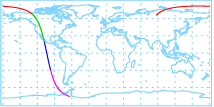
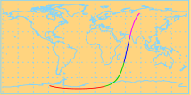
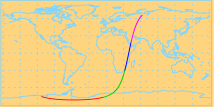
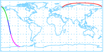
The orbit track locations for the entire Level 1 .hdf file are in black and the orbit track locations corresponding to this page are color coded.

For the full scale images:

  • the color bars for attenuated backscatter show the colors assigned to ranges of attenuated backscatter, /km/sr
  • the horizontal axes are annotated with latitude (deg) and longitude (deg)
  • the vertical axes are annotated to indicate altitude in kilometers
  • the date and time of the measurements are listed as UTC time
  • the names of the CALIPSO data products for the Lidar Level 1 attenuated backscatter granules are included

The scaled images on this page are organized by CALIPSO data product day and night orbit granules.

The maps with a shaded background indicate nightime measurements.

There are a maximum of 4 scaled images per granule.

The orbit tracks plotted on the maps show the measurement locations for each granule.

For each granule, the scaled images are ordered from left to right and their locations along the orbit tracks are color coded as: image one, image two, image three, image four.

/calipso-imagery/data/BROWSE/production/V5-00/2009-04-20/2009-04-20_V5.00_name_map.png image missing
/calipso-imagery/data/BROWSE/production/V5-00/2009-04-20/2009-04-20_V5.00_day_map.png image missing /calipso-imagery/data/BROWSE/production/V5-00/2009-04-20/2009-04-20_V5.00_night_map.png image missing
/calipso-imagery/data/BROWSE/production/V5-00/2009-04-20/2009-04-20_V5.00_arctic.png image missing /calipso-imagery/data/BROWSE/production/V5-00/2009-04-20/2009-04-20_V5.00_antarctica.png image missing

Begin
End Number Profiles
2009/04/20 20:14:41.9260 UTC 2009/04/20 20:22:28.3174 UTC 9405
images/map_thumbnail_not_available.jpg image missing images/thumbnail_not_available.jpg image missing images/thumbnail_not_available.jpg image missing images/thumbnail_not_available.jpg image missing images/thumbnail_not_available.jpg image missing


Begin
End Number Profiles
2009/04/20 20:22:28.3669 UTC 2009/04/20 21:14:55.2224 UTC 63450
/calipso-imagery/data/BROWSE/production/V5-00/2009-04-20/2009-04-20_20-22-28_V5.00_thmb_map.png image missing /calipso-imagery/data/BROWSE/production/V5-00/2009-04-20/2009-04-20_20-22-28_V5.00_1_thmb.png image missing /calipso-imagery/data/BROWSE/production/V5-00/2009-04-20/2009-04-20_20-22-28_V5.00_2_thmb.png image missing /calipso-imagery/data/BROWSE/production/V5-00/2009-04-20/2009-04-20_20-22-28_V5.00_3_thmb.png image missing /calipso-imagery/data/BROWSE/production/V5-00/2009-04-20/2009-04-20_20-22-28_V5.00_4_thmb.png image missing


Begin
End Number Profiles
2009/04/20 21:14:55.2720 UTC 2009/04/20 22:01:21.3174 UTC 56175
/calipso-imagery/data/BROWSE/production/V5-00/2009-04-20/2009-04-20_21-14-58_V5.00_thmb_map.png image missing /calipso-imagery/data/BROWSE/production/V5-00/2009-04-20/2009-04-20_21-14-58_V5.00_1_thmb.png image missing /calipso-imagery/data/BROWSE/production/V5-00/2009-04-20/2009-04-20_21-14-58_V5.00_2_thmb.png image missing /calipso-imagery/data/BROWSE/production/V5-00/2009-04-20/2009-04-20_21-14-58_V5.00_3_thmb.png image missing /calipso-imagery/data/BROWSE/production/V5-00/2009-04-20/2009-04-20_21-14-58_V5.00_4_thmb.png image missing


Begin
End Number Profiles
2009/04/20 22:01:21.3670 UTC 2009/04/20 22:53:48.2234 UTC 63450
/calipso-imagery/data/BROWSE/production/V5-00/2009-04-20/2009-04-20_22-01-23_V5.00_thmb_map.png image missing /calipso-imagery/data/BROWSE/production/V5-00/2009-04-20/2009-04-20_22-01-23_V5.00_1_thmb.png image missing /calipso-imagery/data/BROWSE/production/V5-00/2009-04-20/2009-04-20_22-01-23_V5.00_2_thmb.png image missing /calipso-imagery/data/BROWSE/production/V5-00/2009-04-20/2009-04-20_22-01-23_V5.00_3_thmb.png image missing /calipso-imagery/data/BROWSE/production/V5-00/2009-04-20/2009-04-20_22-01-23_V5.00_4_thmb.png image missing


Begin
End Number Profiles
2009/04/20 22:53:48.2730 UTC 2009/04/20 23:40:15.0604 UTC 56190
/calipso-imagery/data/BROWSE/production/V5-00/2009-04-20/2009-04-20_22-53-53_V5.00_thmb_map.png image missing /calipso-imagery/data/BROWSE/production/V5-00/2009-04-20/2009-04-20_22-53-53_V5.00_1_thmb.png image missing /calipso-imagery/data/BROWSE/production/V5-00/2009-04-20/2009-04-20_22-53-53_V5.00_2_thmb.png image missing /calipso-imagery/data/BROWSE/production/V5-00/2009-04-20/2009-04-20_22-53-53_V5.00_3_thmb.png image missing /calipso-imagery/data/BROWSE/production/V5-00/2009-04-20/2009-04-20_22-53-53_V5.00_4_thmb.png image missing


Begin
End Number Profiles
2009/04/20 23:40:15.1100 UTC 2009/04/21 00:32:41.9674 UTC 63450
/calipso-imagery/data/BROWSE/production/V5-00/2009-04-20/2009-04-20_23-40-18_V5.00_thmb_map.png image missing /calipso-imagery/data/BROWSE/production/V5-00/2009-04-20/2009-04-20_23-40-18_V5.00_1_thmb.png image missing /calipso-imagery/data/BROWSE/production/V5-00/2009-04-20/2009-04-20_23-40-18_V5.00_2_thmb.png image missing /calipso-imagery/data/BROWSE/production/V5-00/2009-04-20/2009-04-20_23-40-18_V5.00_3_thmb.png image missing /calipso-imagery/data/BROWSE/production/V5-00/2009-04-20/2009-04-20_23-40-18_V5.00_4_thmb.png image missing