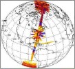
CERES Examples:
Spatial Extent and Scan Modes
The first three images shown below show the areal coverage for each satellite the CERES instrument(s) flies on. In particular, the images show top of atmosphere all sky longwave measurements. CERES ERBE-like instantaneous ES-8 and monthly averaged ES-4 global browse images are available from the CERES Browse Products page.
The second three images shown below show the areal coverage and characteristics of particular CERES scan modes performed by the CERES instruments. The Cross-Track mode, a Fixed Azimuth Plane Scan (FAPS), are cross-track swaths which overlap to generate complete global coverage in 24 hours. CLAMS-Scan is the instrument initially in Rotating Azimuth Plane Scan (RAPS) and switching to a Programmable Azimuth Plane Scan (PAPS) to collect measurements over the Chesapeake Lighthouse and Aircraft Measurements for Satellites (CLAMS) site. The Special-Scan image is an example of a PAPS mode used to collect measurements for an Angular Directional Model study. CERES instrument scan modes are provided from the CERES Operations in Orbit web page.


