Multi-Angle Imager for Aerosols
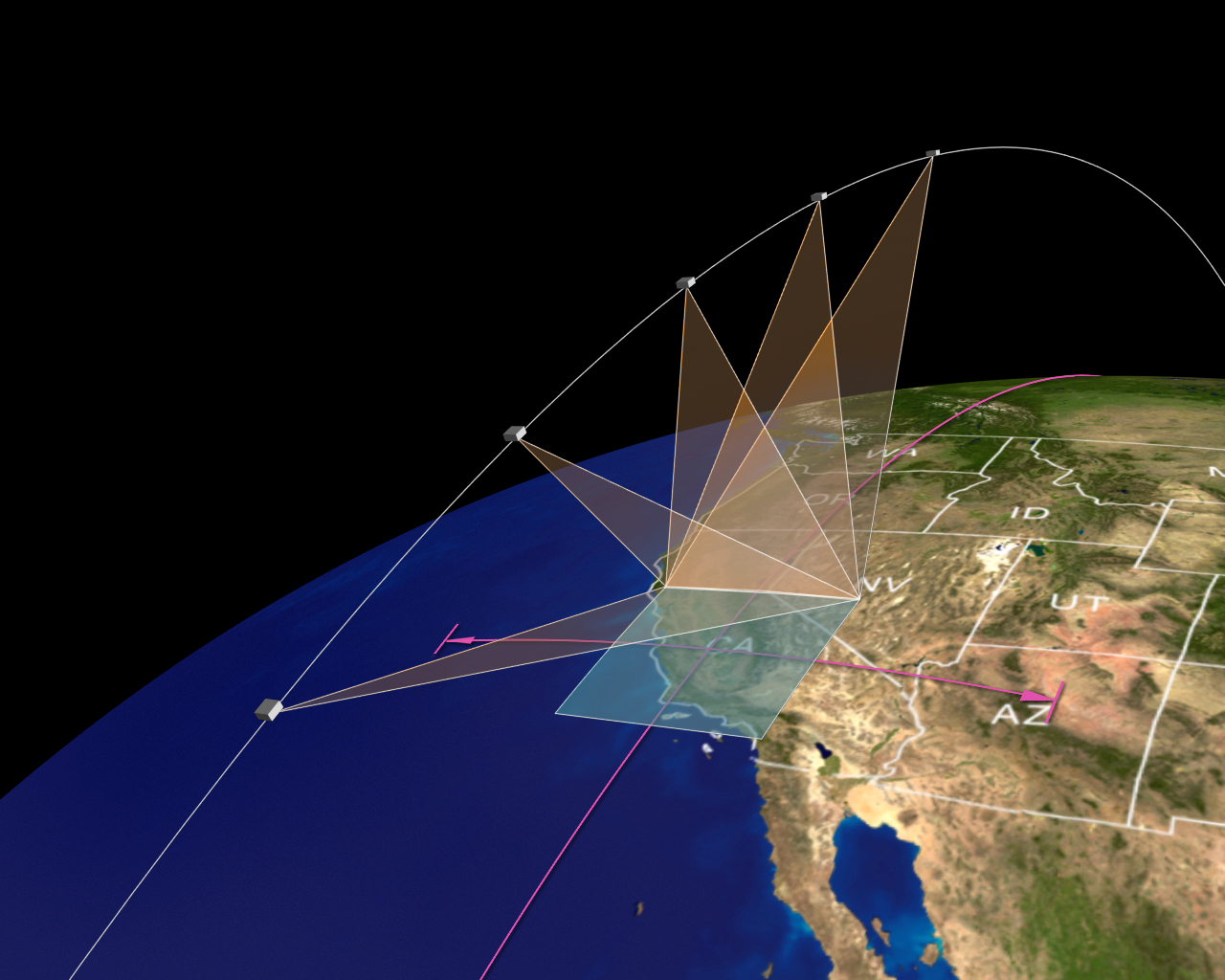
MAIA is an instrument designed to view Earth with a spectropolarimetric camera mounted on a two-axis gimbal. As the instrument flies overhead on the spacecraft, each of MAIA’s target areas is imaged multiple times at different viewing angles by successive repointing of the camera by the gimbal (a mode referred to as step-and-stare), or is imaged by slewing the gimbal slowly as the spacecraft overpasses the target (a mode referred to as sweep). Observations are captured in 14 wavelengths ranging from the ultraviolet to the shortwave-infrared, and polarimetric information is also captured in three of these wavelengths. The goal of MAIA is to improve our understanding of the health effects of different mixtures of particulate air pollution.
Planned MAIA data products
The MAIA project will deliver the following data products, which will be generated, stored, and distributed at NASA’s Atmospheric Science Data Center (ASDC). MAIA’s core data products will be produced in NetCDF format, with metadata conforming to ISO-3166-1 & ISO-8601 and ISO Metadata Evolution for NASA Data Systems (MENDS) standards. Browse imagery and other ancillary products will also be produced.
Generation of all levels of data products will occur in the Primary Target Areas (PTAs) and selected Secondary Target Areas (STAs). Only some product levels will be available in other STAs, Calibration/Validation Target Areas (CVTAs), and Targets of Opportunity (TOOs).
| Name | Description | Expected first public data release at ASDC | Expected median data latency after first release |
|---|---|---|---|
| Level 1 Radiance and polarization imagery | Calibrated and georectified Stokes parameters describing radiance and linear polarization; view and solar geometry; latitude and longitude | <6 months after instrument checkout | <12 weeks from receipt of telemetry |
| Level 2 Cloud-screened aerosol properties | Cloud-screened total and fractional aerosol particle properties at time of satellite overpass | <12 months after instrument checkout | <8 weeks of completion of Level 1 processing |
| Level 2 24-hour averaged PM concentrations on overpass days | 24-hr averaged concentrations of coarse PM, fine PM, and fine PM components on days and locations coincident with cloud-free and quality-controlled instrument observations of the MAIA PTAs | <12 months after instrument checkout | <8 weeks of completion of Level 1 processing |
| Level 4 Gap-filled, daily, 24-hour averaged PM concentrations | Spatially and temporally gap-filled 24-hour averaged concentrations of daily coarse PM, fine PM, and fine PM components over the MAIA PTAs | <18 months after instrument checkout | <8 weeks of completion of Level 2 processing |
Disciplines: Aerosols
| Collection | Disciplines | Spatial | Temporal |
|---|---|---|---|
|
MAIA_ANC_SURFACEMONITOR_PM_2.5_SPECIES_C01
Ancillary speciated PM data from the MAIA Surface Monitor Network |
Aerosols |
Spatial Coverage: (S: -90, N: 90), (W: -180, E: 180) |
Temporal Coverage: 2021-01-01 - Present |
|
MAIA_ANC_SURFACEMONITOR_PM_TOTAL_C01
Ancillary total PM data from the MAIA Surface Monitor Network |
Aerosols |
Spatial Coverage: (S: -90, N: 90), (W: -180, E: 180) |
Temporal Coverage: 2021-01-01 - Present |
| Collection | Disciplines | Spatial | Temporal |
|---|---|---|---|
|
MAIA_L1A_POLCAL_FM_V01p00p00
Polarimetric calibration pre-launch simulated data V01p00p00 |
Radiation Budget |
Spatial Coverage: (S: -90, N: 90), (W: -180, E: 180) |
Temporal Coverage: 2022-01-01 - 2025-12-31 |