Firing Up Our Understanding of the Atmosphere: A Look into FIREX-AQ
Firing Up Our Understanding of the Atmosphere: A Look into FIREX-AQ
With the occurrence of every annual fire season, fire becomes a more pressing issue as the news is inundated with stories of wildfires raging across the western coast of North America. Though visible smoke from fires dissipates, emissions from the fires can remain in the air long after fires stop burning. However, despite the increasing prevalence of severe fire seasons and these lingering emissions, the science behind the emissions of fires is poorly understood. Several processes control the potential emissions of fires, including types and conditions of fire fuels, intensity of fires, and weather related to fires. The measurement of these processes is typically conducted using satellite imagery, which can be used to create models that predict the general seasonal patterns of fires; however, scientists wish to improve these models to provide more detailed predictions of factors and processes related to fires. Completed during summer 2019, the Fire Influence of Regional to Global Environments and Air Quality (FIREX-AQ) field campaign utilized a combination of instrumented airplanes, satellites, and ground-based instrumentation to explore emissions from wildfires and prescribed fires to assess the satellite's capability for detecting fires and estimating fire emissions. FIREX-AQ was an interagency effort between NASA and NOAA based at central locations in the United States in Boise, Idaho and Salina, Kansas. Ambient observations were collected during FIREX-AQ to address the chemistry, transport, and composition of smoke from wildfires and prescribed agricultural burning. The measurements collected during FIREX-AQ aimed to improve climate modeling, to inform decision makers, and to validate satellite observations of wildfire and prescribed fire emissions.

Image Source:
NASA
Spatial Coverage:
[N: 60°, W: -135°, E: -75°, S: 15°]
Temporal Coverage:
July - September 2019
Scientific Objectives
- Collect measurements of trace gas and aerosol emissions from wildfires and prescribed fires.
- Relate measurements to fuel and fire conditions at point of emission.
- Characterize conditions relating to plume rise.
- Follow plumes downwind to understand chemical transformation and air quality impacts.
- Assess efficacy of satellite detections for estimating the emissions from sampled fires.
Phenomena Studied
Instruments Used
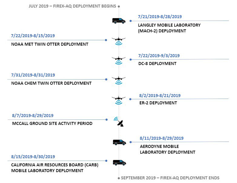
FIREX-AQ scientists collected data using a variety of platforms, including airborne, mobile, and ground-based. These measurements collected with the instruments on the platforms were used in conjunction with various satellite data. The following table goes briefly into the instruments and payloads used in FIREX-AQ, but a more extensive list can be found in the FIEX-AQ overview paper.
| Platform Type | Platform | Relevant Instrument | Study Area |
|---|---|---|---|

|
DC-8 |
Differential Absorption Lidar (DIAL-HSRL), Differential Absorption Carbon monOxide Measurement (DACOM), In-Situ Measurements of Aerosol Optical Properties (AOP), Langley Aerosol Research Group Experiment (LARGE) |
Collected in-situ and remote sensing measurements of aerosol properties, trace gases, cloud droplet properties, actinic flux, and photolysis coefficients. |

|
ER-2 |
Airborne Multi-angle SpectroPolarimeter Imager (AirMSPI), Cloud Physical Lidar (CPL), National Airborne Sounder Testbed-interferometer (NAST-I), Scanning High-Resolution Interferometer Sounder (S-HIS) |
High-altitude research aircraft with satellite simulator instruments to characterize fires and fire plumes. |

|
NOAA Twin Otter |
Tenax Cartridge Autosampler, Scanning Micropulse Doppler Lidar, Iodide-ToF-CIMS |
Collected in-situ measurements of aerosol properties, trace gases, photolysis coefficients, and meteorology. |

|
Aerodyne Mobile Laboratory |
Tunable Infrared Direct Absorption Spectroscopy (TILDAS), Vocus-Proton Transfer Reaction (PTR) Mass Spectrometer, High-Resolution Aerosol Mass Spectrometer (AMS) |
Investigated fire-impacted valley towns from the McCall, ID base location, as well as traveling to more distant fires across the western portion of the FIREX-AQ campaign. |

|
NASA Langley Mobile Laboratory (MACH-2) |
Filter/Ion Chromatography, Mist Chamber/Ion Chromatography, Colorimetry and IRMS, Aerodyne CAPS |
Studied aerosol and trace gas measurements related to wildfires and the interaction of aerosol and trace gases. |

|
California Air Resources Board (CARB) Mobile Laboratory |
Picarro G2401, 2B Ozone and NOx, Magee Sci. Aethalometer AE33 |
Studied interactions between urban and wildfire emissions in California. |

|
McCall, Idaho Ground Site |
Aerosol Chemical Speciation Monitor (ACSM), ARIsense Airmar Weather Station 200WX, Micro Pulse Lidar |
Housed instrumentation from numerous teams, including the Aerodyne Mobile Laboratory, NSF Mobile Lab, and LCSC VOC group. |

|
Aerosol Robotic Network (AERONET) |
CIMEL Lidar, Microtops II, Calitoo, PLASMA |
Data contributed from Distributed Regional Aerosol Gridded Observation Network (DRAGON-FIREX-AQ 2019). |
Access Data
The ASDC archives and distributes publication-quality data from a variety of the platforms used during FIREX-AQ. Data collections are defined on the ASDC FIREX-AQ Landing Page. Data can be accessed using the Sub-Orbital Order Tool (SOOT), the ASDC Website, or through Earthdata Search. For more information regarding the MODIS/ASTER Airborne Simulator (MASTER) instrument data for FIREX-AQ, please refer to the Oak Ridge National Laboratory (ORNL) website: ORNL MASTER FIREX-AQ Data.
Events of Interest
This section highlights events within the field campaign of particular scientific interest.

The deployment on the platforms detailed above for FIREX-AQ offered rare opportunities to capture in-situ and remote sensing measurements from fires. Throughout FIREX-AQ, the multiple platforms captured many plumes from hundreds of fires, providing a comprehensive set of measurements. An example of one of these fires was the "Castle" fire sampled through August 12-13, during which FIREX-AQ scientists explored the chemical composition, evolution, and transport of emissions in plumes throughout the fire's lifespan. Additional details about the sampling of the "Castle" fires are available in a NASA Earth Observatory article.
Another event of interest was the capture of the formation of a pyrocumulonimbus cloud (PyroCb) from the "Williams Flat" fire on August 8, 2019. PyroCbs occur when heat and moisture created from fires lead to thunderstorms and are capable of sending aerosols high into the atmosphere, with some events injecting aerosols directly into the stratosphere. The "Williams Flats" fire produced a large pyroCb that FIREX-AQ scientists were able to capture on the day's DC-8 science flight. The sampling conducted during the flight was one of the most detailed samplings ever conducted on a pyroCb and was complemented by measurements from the ER-2 as well as the ground and mobile platforms deployed at the time. More information about the August 8th pyroCb capture is available in a NASA Earth Observatory article.
Relevant Publications
Warneke, C., Schwarz, J., Ryerson, T., Crawford, J., Dibb, J., Lefer, B., Roberts, J., Trainer, M., Murphy, D., Brown, S., Brewer, A., Gao, R., & Fahey, D. (2018) Fire Influence on Regional to Global Environments and Air Quality (FIREX-AQ): A NOAA/NASA Interagency Intensive Study of North American Fires [White paper]. NASA and NOAA. https://www-air.larc.nasa.gov/missions/firex-aq/docs/whitepaper.pdf
Warneke, C., Schwarz, J. P., Dibb, J., Kalashnikova, O., Frost, G., Al-Saad, J., et al. (2023). Fire influence on regional to global environments and air quality (FIREX-AQ). Journal of Geophysical Research: Atmospheres, 128, e2022JD037758. https://doi.org/10.1029/2022JD037758
Reference Sources
NASA Earth Expeditions Article "Plumes Go the Distance"
NASA Earth Observatory Article "Flying Through a Fire Cloud"
NASA Earth Observatory Article "Sampling the Castle Fire"
FIREX-AQ NASA Earth Expeditions Posts
NOAA Chemical Sciences Laboratory (CSL) Overview of FIREX-AQ